Overview
General information
geocat.ch is the metadata catalogue for Swiss geodata. Federal offices, cantons, municipalities and even private companies publish metadata about their own geodata in geocat.ch. The aim and mission of the catalogue is the central publication of geometadata. It thus serves as an ideal entry point for specific geodata searches in Switzerland.
The catalogue is managed by the Coordination, Geographic Information and Services Division (COGIS) of the Federal Office of Topography swisstopo on behalf of the federal coordination body for geoinformation (GCS).
Metadata are an essential element for the construction and operation of a spatial data infrastructure. The linking between the metadata published in geocat.ch and the federal geoportal geo.admin, including its map viewer map.geo.admin.ch and the opendata portal opendata.swiss, is central. Most cantonal and municipal metadata are also directly linked to the respective geoportals. The link to the European portals INSPIRE and European Dataportal considerably increases the scope of information on data availability.
geocat.ch is based on the GeoNetwork opensource application. It has been in use since 2004 and is continuously developed and adapted to the needs of users.
The catalogue is constantly completed and updated with metadata. Metadata must be entered in accordance with the GM03 standard to be valid and published in geocat.ch.
Metadata search
In addition to the direct search in the graphical user interface, geocat.ch offers the possibility of direct access to existing metadata via an API or a CSW service.
Collecting metadata
Would you like to publish your geometadata on geocat.ch and become a geocat.ch partner?
If so, please contact us so that we can find the best solution for you.
The following diagram shows the different options for a partnership. Everyone is free to choose their own type of partner, depending on their situation and needs.
geocat.ch partnership models
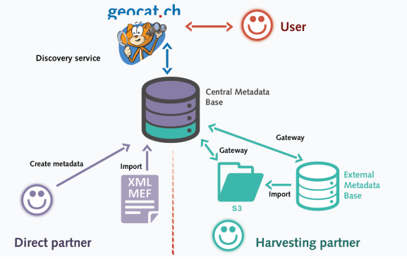
Direct partners
Direct partners can enter and manage their metadata directly in the geocat.ch application or via the API.
They can :
- Define users with their own rights.
- Import and export metadata.
- Create templates with predefined content.
- Enter and use contacts as reusable objects.
- Use formats and extensions for reusable objects.
- Publish and unpublish metadata records.
Detailed information and instructions are available here (in German).
A) Harvesting partners (S3)
S3 harvesting partners receive access to the S3 server operated by swisstopo. The metadata they upload as XML or .mef files are then harvested by geocat.ch at a predefined interval, i.e. they are retrieved and published in the catalogue.
B) Harvesting partners (CSW)
CSW harvesting partners store their metadata in their own database. geocat.ch requests the metadata via the search service according to the OGC CSW 2.0.2 standard and automatically publishes the resulting information.
Features :
- High degree of automation.
- Synchronisation between catalogues/databases.
- No editing in geocat.ch
- No validation on the geocat.ch page
Detailed information on harvesting can be found here (in German).
Access to geocat.ch (organisation registration and user account)
You do not need a password to perform a metadata search.
The metadata editor is password protected.
For each new group (organisation) we create an account with the rights of a user administrator. A user administrator can then create other user accounts with different rights within their own group. If a group already exists for you, you will receive your user account from your group administrator.
The following information is required:
Group: Name of your organisation/group (if desired in several languages) and a logo (as a .png or .jpg file).
User account: Contact details of the person (name, first name and e-mail).
Registration is done by e-mail to geocat@swisstopo.ch.
There is no automatic access to the test server. If you need to perform tests, please contact us.
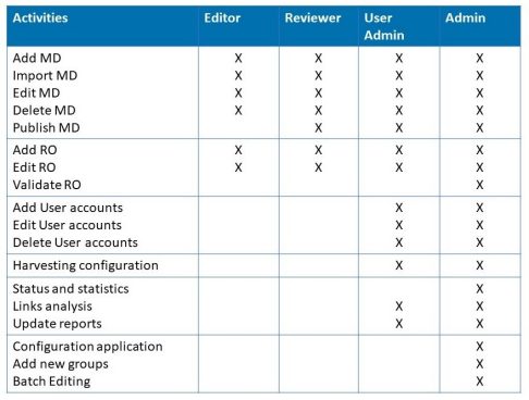
User rights in geocat.ch
Legal notice and terms of use
Anyone wishing to publish geometadata from Switzerland (including Liechtenstein) may use the geocat.ch application.
The conditions of use of geocat.ch are described in the Legal notice and conditions of use of the geocatalogue "geocat.ch".
Users of geocat.ch are obliged to read this document.
-
TermsOfUse_geocat_EN.pdf
Legal notice and conditions of use of the geocatalogue "geocat.ch"
PDF, 2 Pages, 184 KB, English