FAQ
With this list we would like to provide you with some answers to frequently asked questions. These are questions and problems of a technical as well as organisational nature concerning the search, recording and handling of geocat.ch.
Please contact us if the answer is insufficient or if further questions arise.
Topics:
General
geocat.ch offers several types of metadata search. Read here which one is best suited for your purpose.
Response:
On the following page of eCH:
eCH-0166 Geokategorien V1.2 - eCH E-Government Standards (External page. Content opens in new window.)
Cause:
The metadata record is no longer published. This happens when the record has become invalid (in the meantime) during editing.
Solution:
Log in and search for the specific metadata record. Check whether the metadata record is valid. If yes, you can publish it. If not, correct or add to the metadata record as suggested in the validation window. After the correction, you can save the metadata record, validate it again and then publish it.
If you do not have publication rights, contact the user administrator of your group. He or she can release the data for you or grant you the necessary rights.
Please note:
After a change to the metadata, the publication status should also be checked.
Direct capture / data management
Response:
There can be two reasons for this:
- It is a mandatory element that you have to fill in. You cannot remove
- You are in the default view and therefore do not see all the nesting:
Switch to the complete view and remove the whole element there by clicking on the x next to the field name.
Automatic updating is possible, for example, via the REST API from geocat.ch. More information is available here.
To check the URLS of your own metadata, you need the rights of the user administrator. In the "Admin console" tab, go to "Statistics and status" > "Record links analysis".
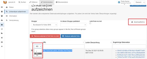
You can display all URLs or only those that are invalid (KO). With a click on "Download as csv" you can write out the result of the analysis as a list.
All metadata of basic geodata published on geocat.ch are automatically harvested and published by the INSPIRE portal. It is triggered by the keyword "official geodata". More information can be found at INSPIRE.
Harvesting
The linking is done via an xlink with the ID of the keyword and a link to the thesaurus concerning.
The keyword ID can be found in the RDF file of the relevant thesauri, which you can download here.
The names of the thesauri are as follows:
- thesaurus=local.theme.geocat.ch
- thesaurus=external.theme.inspire-theme
- thesaurus=external.theme.gemet-theme
Example:
xlink:href="local://srv/api/registries/vocabularies/keyword?skipdescriptivekeywords=true&
thesaurus=local.theme.geocat.ch&
id=http://geocat.ch/concept#179,&lang=fre,ita,eng,ger"
For more information on the keyword description in the XML, see the manual (geodata).
opendata.swiss
The exact description must be entered in the text field in order for the mapping of the terms of use to opendata.swiss to work. If this is not the case, a default term of use is displayed, which can be defined in the harvesting configuration in the opendata.swiss portal (for this, it is best to ask the geocat.ch team or opendata.swiss directly).
Detailed information on the correct entry of the terms of use can be found in the manual (geodata).